
Icelandic Place Names
Understanding the places where your ancestors were born, lived and died can be confusing. This is because there are often multiple names, or combinations of names for the same location. Following is some information that is useful to decipher place names that you will find in the genealogical database, census records or other Icelandic text.
For most of Iceland's history, almost the entire population lived on farms. In 1800, Reykjavik only had a population of 600, about 1% of the total population! Sauðárkrókur, the largest town in Skagafjörður did not exist before 1871 and there were only a few hundred people by at the turn of the century. The address of almost all people was the farm where they lived. Each farm had a name, often taken from a geographic feature.
Iceland was partitioned into:
-
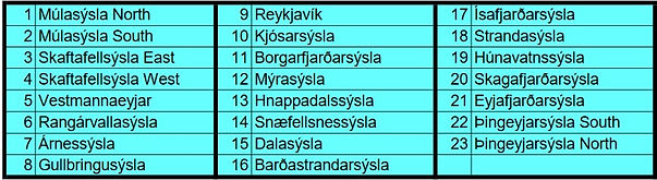
18 Sýsla or counties
-
and then 169 Hreppur (Districts or Municipality)
-
and then 290 Sókn (Parishes)
These have changed over the years. Following is a map of counties during the emigration period.

A given farm name may exist in several places in Iceland, so to distinguish among them and also to describe the location of a farm, the farm is very often listed with some combination of the above partitions, e.g.
farm, district, county
farm, parish, county
Here is a current map of Iceland that has a search facility to locate farms. (Click on the "basemap" button and change it to "map with place names" and then zoom in to find farms and geographic features. There is a search area at the top right where you can enter a farm name)
Locations mean much more if you can understand the component words of their names. Following are a few common places along with the derivation of their names.

Here is a longer list of words which are commonly used in farm names and features found on maps.