
Saskatchewan Icelandic History Driving Tour

by Karen Pytlowany
and Shaune Jonasson
Icelandic settlements in North America progressed west over the years with many settlers filing homestead grants in Saskatchewan. Fewer came directly from Iceland, whereas numerous settlers arrived from the Argyle district in Manitoba, North Dakota and Minnesota. Wherever they moved from, the Icelanders sought a better life here. Many of them found what they wanted in Saskatchewan. You can read about the settlement of Saskatchewan here: Icelandic Settlements - The Saskatchewan Story.
Continuing the migration from the settlements in Manitoba and following the trek to settle in Saskatchewan, our driving tour will begin in the eastern part of the province following Highway (Hwy) 16 for most of the journey, with a few possible jaunts of that path.

The distance between the settlement areas from its shared border with Manitoba to Dafoe, Saskatchewan, it is a 250 km (155 miles) stretch along Hwy 16, also known as the Yellowhead Highway. This gives us beautiful panoramic views of prairie scenery.
CHURCHBRIDGE
Churchbridge is situated approximately 40km (25 miles) northwest from the provincial border. Using Churchbridge as a pivot point, the traveller can visit Thingvalla Logberg, and the Tantallon District.
Thingvalla and Logberg are where we find the Icelandic settlements. Thingvalla was the first settlement in Saskatchewan in 1885.
Travelling to this area, readers are encouraged to visit the Heritage Cemeteries Project Inc., a non-profit charitable organization of volunteers established in 2004, who have embraced the responsibility of maintaining, preserving, and restoring the region’s historical churches and cemeteries, including those of our Icelandic ancestors. An incredible undertaking with amazing results is visible on the site. It lists the churches and cemeteries with the background of each one. Many of the directions provided and the images used for the RM of Churchbridge have been shared with permission from the Heritage Cemeteries Project.

Departing from Churchbridge, we travel for about 6 km (3.7 miles). Take Hwy 80 north, arriving at Thingvalla Rd, travel east for 2.4 km (1.5 miles), then head north for 1.6 km (1 mile), and east again for 1.2 km (¾ mile).
You will arrive at Thingvalla, a municipal heritage property settled in 1885, with the cemetery added in 1887. The original church was built in 1888, known as the Thingvalla Icelandic Lutheran Church of America. That church was replaced in 1910 with the one you see erected on the property, an active venue for many years. At the cemetery, there is a plaque identifying those who lie in eternal rest. That list is also available for viewing at Heritage Cemeteries' website.

Logberg is just over 25 km (15 miles) from Churchbridge. Travel north on Hwy 80 for approximately 19 km (12 miles), turn east onto a grid road, SK-381, and travel for approximately 4.8 km (3 miles). If you are travelling from Thingvalla, backtrack to where you intersect Hwy 80, then travel north until you reach the grid road SK-381, as above.
A roadside marker will welcome you to the Logberg area. Travelling north from here for another 1km (1/2 mile), you will reach the cemetery.

Logberg was first settled in 1890. The settlers, initially joining the Thingvalla congregation, completed their own church in 1905, soon becoming a community hub. In February 1914, a steeple was added. The church closed in 1953 when a local person moved it to “the west side of Calder Road, south of the town,” making it his home. It still remains there according to the Heritage Cemeteries Project Inc. site.
Tantallon District includes the villages and towns of Tantallon, Spy Hill and Stockholm

The 1924 Rand McNally map of the Early Icelandic Settlements more clearly indicates the areas settled in relation to each other.
This trek will take you south through gently rolling prairie to the north and east portion of the picturesque Qu’Appelle Valley. Travel south on Hwy 80 from Churchbridge for 21.4 km (13 miles) until you reach Yarbo. Then turn left and follow this road for 7 km (4.3 miles), where you will turn left onto SK – 22E. Travel 7 km (4.3 miles), then turn south, following that road for 14.3 km (9 miles) into Tantallon.

The Tantallon settlement began in 1887, and by 1894 they had built a community hall used for both school and church services. In 1909, Hólar school was built and used as a school for ten years, then became a community hall. Hólar Hall, as it was called, was moved to the village of Tantallon where it was restored as a heritage building.
YORKTON
Travelling northeast for 53 km (33 miles) from Churchbridge, we arrive in Yorkton. This city was settled by many ethnicities and nations, becoming a business hub for many smaller towns and villages.

The Western Development Museum recently revitalized its Icelandic Exhibit showcasing the Icelandic settlements on the prairie, including the story of Gudrun Bjornsson, whose many belongings are on display. Continue to travel through the town following the Hwy 16 signs heading northwest to the museum, located at the edge of the city. (Image sourced from The Western Development Museum.)
FOAM LAKE
Foam Lake was settled in 1909. The name originated in the late 1800s from early Icelandic pioneers who saw foam on the shores of the current Foam Lake Heritage Marsh on a windy day. The Icelandic settlers in the area contributed significantly to the community’s agricultural development and cultural life.
Foam Lake Heritage Marsh is home to many indigenous species of waterfowl, as well as a diverse habitat for other land and water animals. The marsh is located about 5.5 kilometers (3 ½ miles) northwest of the current town. The construction of the observation area and trail will satisfy both birdwatchers and nature lovers. The Vatnabyggd Trail is a short 3.2 km hiking trail near Foam Lake’s Heritage Marsh for birdwatching and nature.

Quill Lakes International Bird Area (Wadena - Wynyard - Foam Lake) covers 250 sq km in a conservation area between Foam Lake, Wadena and Wynyard. One of two main centres for the Quill Lakes is located in Foam Lake, the other in Wynyard (see the information further in this article). The Foam Lake Visitor Centre & Nature Centre has tourist information, campsites, a golf driving range, a heritage home, nature and walking trails and interpretive nature displays.
Bertdale School was opened in 1899 as a one-room, wood-frame schoolhouse constructed of logs by volunteer labour. Community growth required a new school, which opened in 1909 with a four-foot bell tower and was in use until the 1950s. The bell from this tower is now housed at the Foam Lake Museum.
Travel north from the centre of town on Hwy S-310 (Cameron Street) for 5 km (3 miles), turn west on Township Road 324. There is an historical marker about the schoolhouse where these two roads intersect.
Foam Lake Museum is located in a beautiful, historic brick building circa 1926, at 113 Bray Avenue, with some Icelandic items on display, including Icelandic books and other related information.
Bertdale Icelandic Cemetery/Bildfell Cemetery, known by both names, is located at GPS 51.674051° N and 103.564813° W on the original homestead of Gisli Bildfell (I517570). Gisli was one of the founding settlers of the Icelandic settlement at Fishing Lake in 1892.
Fishing Lake is 22 km (13.5miles) north of Foam Lake on Highway 310. In 1895, Gisli donated the land for the cemetery, which is said to be exclusively an Icelandic cemetery. There are 106 memorials there with Icelandic names such as Halldorson, Einarson, Olafson, Thorlacius, and Narfason.
ELFROS
The village of Elfros, located 25 km (15.5 miles) northeast of Foam Lake, is deeply rooted in Icelandic history, settled mainly by Icelandic immigrants in the early 1900s. The settlers were attracted to this area’s abundance of land, hay, and water.
Vatnabyggd Icelandic Pioneer Memorial, unveiled in 1988, is a bronze statue that depicts a young couple in turn-of-the-century Icelandic dress. The wife knits while the husband reads poetry to her.

This work was the result of an idea between Eric Stephanson (I200773) and his wife, Stella, who believed that a commemoration of the largest area of Icelandic settlements in Canada was necessary. They formed The Vatnabyggð Icelandic Club of Saskatchewan in 1981.
This project was a tremendous undertaking, as heard in the interview recorded with Stella Stephanson, Vatnabyggd Icelandic Pioneer Memorial posted on YouTube on 26 August 2017.
Additionally, there is a drone video of Elfros, Saskatchewan from Cheryl’s Videos and Pics (8 ½ minutes) where the memorial is seen at minute 5. The remainder of the drone footage shows the landscape of the village of Elfros and the town.

Elfros Union Church, a municipal heritage property at 301 Elfros Street, was built by the local Lutheran and Presbyterian faiths. They merged their resources to build the wood-framed, one-story church with a steeple, completing it in 1935.
Elfros Cemetery is located about 1 km south of the village (SW-13-32-14-W2) across Hwy 16 where Nacka St and Range Road 2141 intersect.
Many Icelandic names can be seen on the headstones, including Johann Magnus Bjarnason (I521874), a teacher/educator, writer, and recipient of the Order of the Falcon. He is laid to rest here alongside his wife, Guðrún Hjörleifsdóttir. IR profiled his book "The Young Icelander" in April 2026.
WYNYARD
Continuing northwest for 40 km (25 miles) is the town of Wynyard, equally distanced from Regina, Saskatoon and Yorkton.

Wynyard Federated Church/ Wynyard Unitarian Church, located at 330 Bosworth Street, is often referred to as the Brick Church. The building was erected in 1921, and over the years many of the church’s design elements have remained the same. It was Canada’s largest Unitarian congregation during the 1930s. In 1982, the church was declared an historic site. Regular services are no longer held; however, funerals and weddings are performed occasionally.
Pleasant View Cemetery is located north of Hwy 16 on the west end of the town. Again, there are an abundance of Icelandic names displayed dating from the earliest immigrants who established the area’s agricultural and cultural foundations.
The Wynyard and District Museum located at 120 Avenue B East showcases the area’s rich history. The museum has authentic artifacts and pictures on display. The building, originally the Sleipnir Store, was brought to its current location. One original wall remains between the museum and the addition which houses the Hospital Auxiliary Thrift Store.
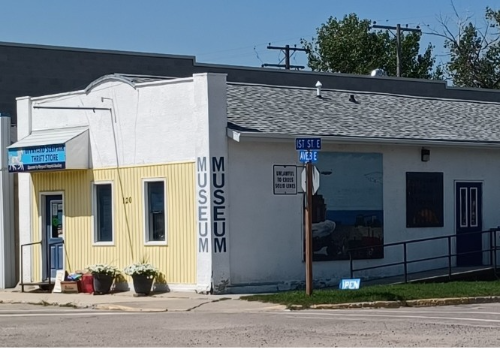
The museum has limited hours, between the end of June through August. Those wishing to visit outside of their posted hours are encouraged to contact the museum. Town of Wynyard - Wynyard and District Museum.
KANDAHAR
Kandahar, 13 kilometres (8 miles) from Wynyard, is located near the southern shore of Big Quill Lake. There is little left to see in this area as the hamlet of Kandahar in 2025 was designated as a special service area, which is an area too small to be deemed a hamlet, and the municipality falls under the nearest designated Royal Municipality.

Mountain School #1548
Travelling to Dafoe, you will notice a dilapidated building, formerly a one-room schoolhouse, known as the Mountain School. The Quill Historical Society in 1988 placed a cairn on the site commemorating the school’s use from 1906–1951.
The Icelandic Cemetery is located between the towns of Kandahar and Dafoe along the south side of the highway, approximately 3 km northwest of Kandahar (9 km/5.5 miles from Dafoe). The GPS coordinates are 51.75157° N and 104.40331° W. There are 170 memorials bearing Icelandic names, with the first burial from 1911. This link to the Icelandic Cemetery will allow you to view those laid to rest.
DAFOE
Dafoe, located at the junction of Highways 6 and 16, is the western boundary of the Vatnabyggð. Driving the 12 km from Kandahar, one can see the southern shore of Big Quill Lake.
The Quill Lakes International Bird Area on the north side of Hwy 16 stretches from approximately Dafoe to Foam Lake to the Wadena area. The Quill Lakes are the largest saline lakes in Canada and home to many endangered species. Over a million birds can be seen in this area while walking the trails. Visit one of the two nature centres, Wynyard or Foam Lake. Wynyard is where the Quill Lake Interpretive Centre can be found. It is advisable to check ahead as this facility is not staffed year-round, although it is open to the public.
Freba Pottery and Studio, also along Hwy 16, is 7 km east (4.3 miles) from Dafoe and is owned and operated by Marea Olafson (I421102). You can visit her studio and shop while travelling by as she has set up purchases through an honour system. This area was originally settled by Johann (Joe) Josephson (I602793), where a two-story wood frame house was built in 1919 by Icelandic carpenters. In 1950, Marea’s Amma and Afi purchased the original house, turning it into a Bed and Breakfast called Amma’s House. More recently, in 2013, Marea and her husband purchased the home. Here’s where you can learn more about Freba Pottery.

There is much to see while travelling along Highway 16 from Churchbridge to Dafoe. It’s not easily done in one day. Additionally, this article did not provide some of the off-highway routes to where the smaller communities or settlements existed. Once one travels and engages with the locals, I am certain that they will provide more information about where to go, what to see, or what to eat. Vatnabyggd is also expansive.
Regardless of where one travels, they’re exposed to the “Land of the Living Skies” with gently rolling hills, creeks meandering, bluffs of poplar and willow, to the flat land of the colourful prairie, especially in the height of summer growing season. Then there are the lakes and their wildlife.
It is no wonder why many of our ancestors chose to settle here. The Icelanders honed their craft to become competent prairie farmers all the while building communities with churches, schools, libraries and social halls. There are many older homes dotting the countryside, most looking frail from time, while others have been replaced.
Happy travels!
Resources and Additional Reading
Heritage Guide https://heritageguide.ca/thingvalla-church-and-cemetery-churchbridge-rm-211-saskatchewan
Historic Places Days, Holar Hall Tantallon, from Historic Places Days Photo cr. R. Lattamus
Icelandic Cemetery in Kandahar Citations: “Adamson, Julia; Ron Isherwood; Judith Bell, and Beverley Keyser (2021, February 21) Icelandic Cemetery Kandahar district Saskatchewan Cemeteries Project. Retrieved Monday, September 21, 2026, from https://sites.rootsweb.com/~cansacem/icelandic.html”
Icelandic Roots
Quill Lakes International Bird Area https://foamlake.com/heritage-marsh/ynyard
Saskatchewan One Room School Project https://sites.rootsweb.com/~cansk/school/Maps/PinkBook/pages/DSC01369.htm
Tourism Saskatchewan Home | Tourism Saskatchewan
Western Development Museum, Yorkton https://wdm.ca/2026/08/17/revitalizing-the-icelandic-exhibit-at-the-wdm-yorkton/
Wynyard and District Museum https://saskmuseums.org/places/wynyard-and-district-museum/


